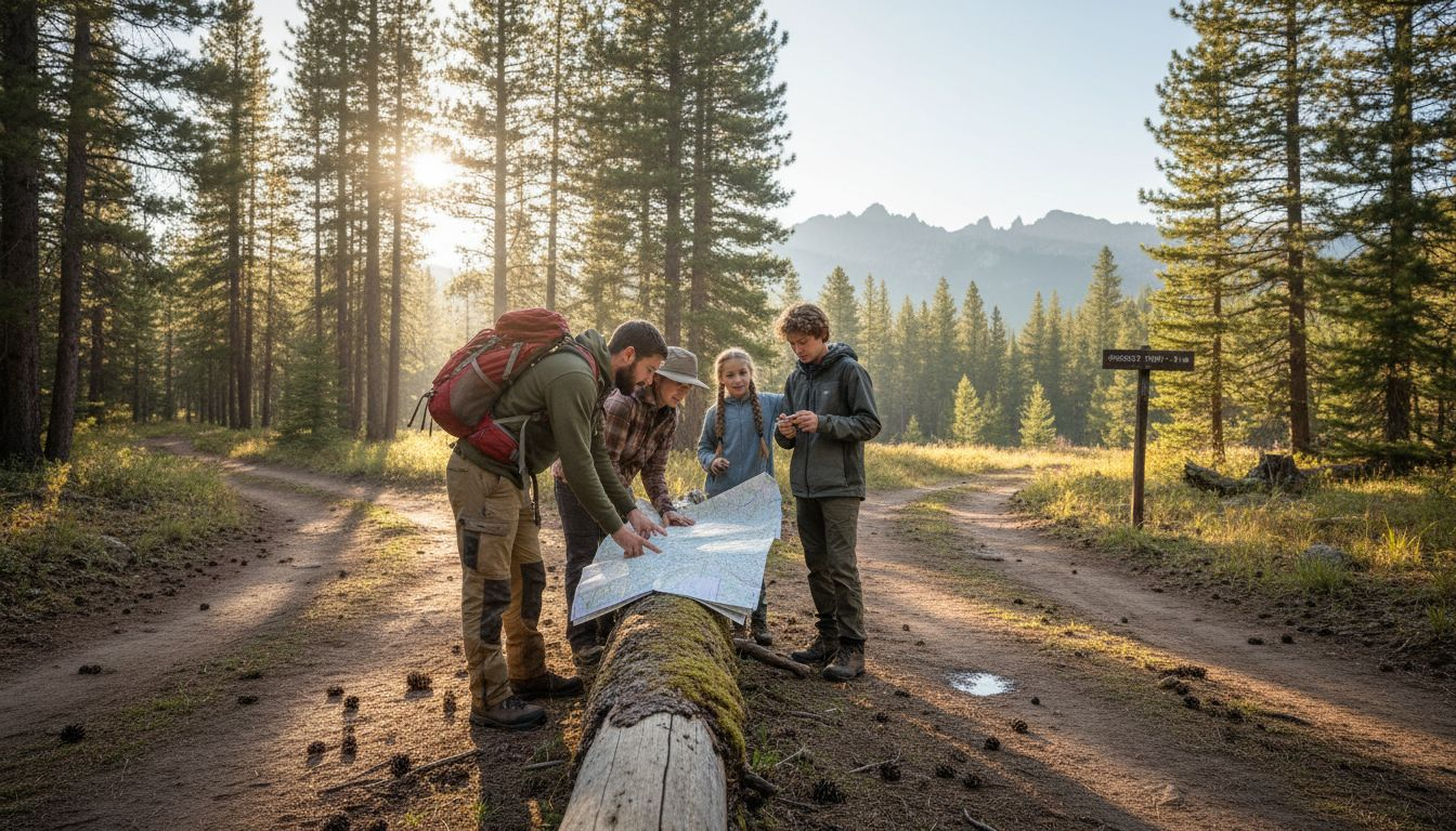
Every parent knows the feeling of stepping onto a trail in Colorado or California and realizing just how quickly wilderness can challenge your sense of direction. Choosing reliable outdoor navigation tools is a must when cell service disappears, trails split, and the terrain becomes unpredictable. This guide explains how core tools like waypoints and tracks help your family stay safe and confident. Discover practical strategies for mastering backcountry navigation and making your Western camping trips both memorable and secure.
Key Takeaways
| Point | Details |
|---|---|
| Importance of Outdoor Navigation | Understanding real-time location, route planning, and offline capabilities are essential for safely navigating remote terrains. |
| Essential Navigation Tools | Carry a map, compass, and GPS device to ensure reliable navigation when one tool fails. |
| Practice and Preparation | Familiarize your family with navigation tools through short hikes to build confidence and competence before longer adventures. |
| Common Mistakes to Avoid | Avoid overrelying on electronics and ensure comprehensive knowledge of map reading to prevent navigation errors in the backcountry. |
Defining Outdoor Navigation and Its Core Purpose
Outdoor navigation is about getting where you need to go in wild places where trails matter more than roads. Unlike turn-by-turn GPS navigation in your car, outdoor navigation focuses on waypoints and tracks across natural terrain.
When you're hiking through Colorado's Rocky Mountains or exploring California's backcountry, your smartphone's map app won't cut it. Outdoor navigation utilizes advanced technologies like GPS, compasses, and altimeters to help you stay on course where cellular coverage disappears and trails fork in unexpected directions.
Why This Matters for Your Family Adventures
The core purpose of outdoor navigation is simple: get your group from point A to point B safely. That means knowing exactly where you are, which direction to go next, and having backup plans when weather or terrain changes.
Consider what happens when you're 8 miles into a canyon hike with your kids and the trail markers fade. Your navigation tools become the difference between a memorable adventure and a stressful situation.
Outdoor navigation serves several critical functions:
- Real-time location tracking so you know your exact position on a map
- Route planning that accounts for elevation, distance, and terrain difficulty
- Offline capability because you won't have cell service in most Western wilderness areas
- Waypoint marking to mark key locations like water sources or campsites
- Emergency communication when you need to call for help and describe your location
How It Differs from Regular Navigation
Standard GPS navigation (like Google Maps) works beautifully on roads. It gives turn-by-turn directions, shows traffic, and updates in real-time. But trails don't have turns like intersections do.
Outdoor-specific tools use topographic maps showing elevation changes, ridge lines, and water features. You'll see contour lines that reveal steep terrain ahead, not just a flat line representing your path.
Your navigation also needs to work without constant internet. Most camping spots in Colorado, Utah, and California lack reliable cellular service, so offline maps and waypoints become your lifeline.
Outdoor navigation is about understanding terrain and location, not following street signs. Your tools must work when digital services fail.
The Real-World Impact
Families who invest in solid outdoor navigation skills and tools return home with great stories instead of scary ones. You move with confidence through unfamiliar terrain, make smarter decisions about route changes, and respond calmly if something goes wrong.
Your kids learn that preparation and knowledge turn wilderness into playground, not danger zone.
Pro tip: Start with a short day hike near your base camp using your navigation tools before attempting longer backcountry routes. This builds confidence and reveals any equipment issues while help is close by.
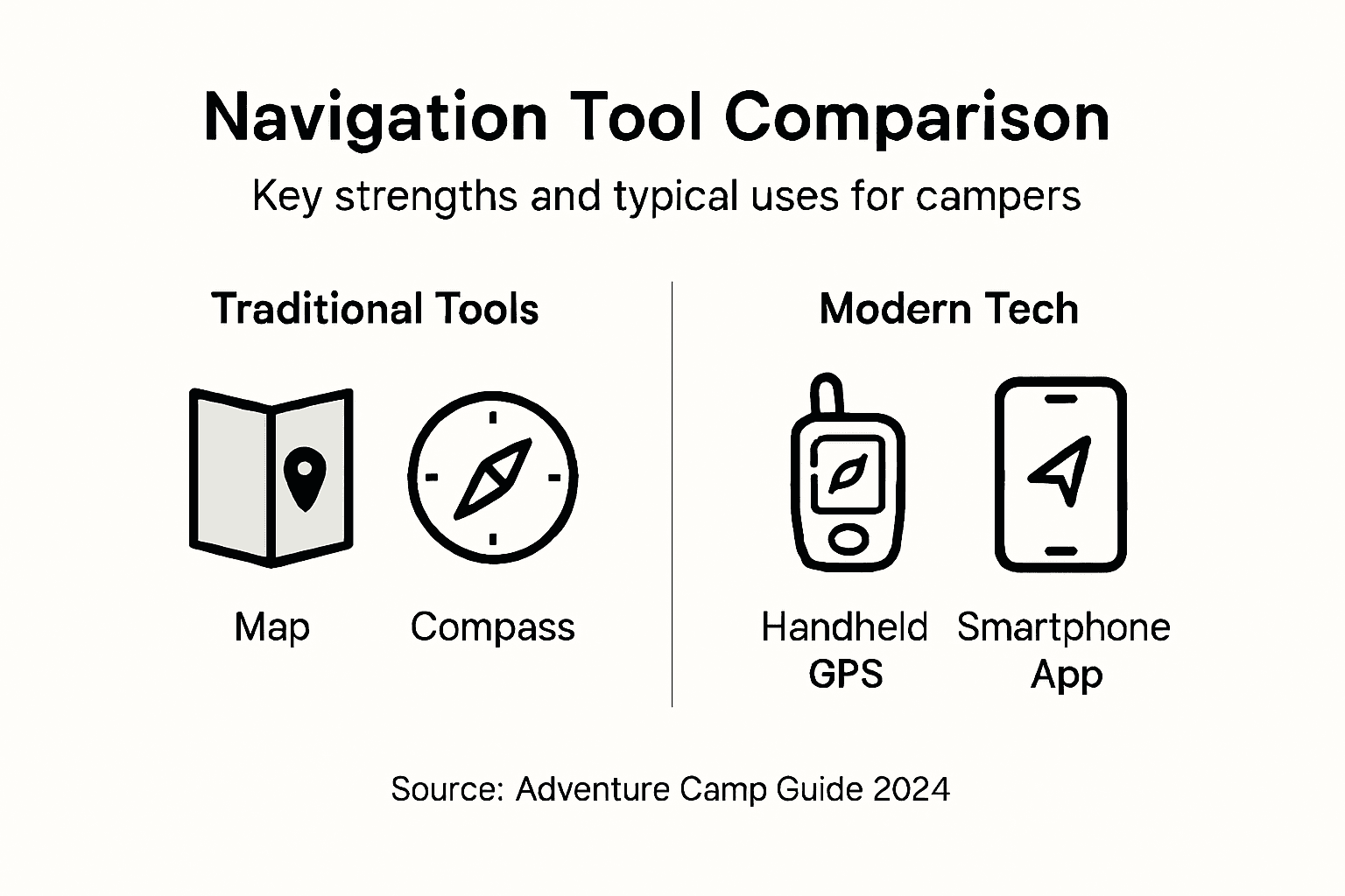
Navigation Tools: Maps, Compass, and GPS Devices
You need three core tools to navigate confidently in the backcountry: maps, compasses, and GPS devices. Each serves a specific purpose, and together they form a reliable navigation system that works when one tool fails.
Maps: Your Visual Foundation
Topographic maps show you the actual terrain you'll encounter. Unlike road maps, they display elevation through contour lines, water features, vegetation, and ridge patterns that reveal steep sections ahead.
When planning a trip through Colorado's mountains or California's deserts, topographic maps let you visualize the landscape before you arrive. You'll see which valleys have water sources, where ridges create challenges, and how elevation changes across your route.
Maps also work without batteries. They don't depend on satellite signals or cellular networks, making them an essential backup to digital tools.
Compass: The Reliable Standby
A compass is your mechanical certainty. It always points north and requires no electricity, no satellites, and no internet connection.
Compass features support orienteering skills like taking bearings and aligning maps to find your location. Combined with a topographic map, a quality compass transforms your ability to navigate accurately.For family camping trips, a compass teaches kids how navigation works mechanically. It builds confidence when electronic gadgets fail.
GPS Devices: Real-Time Positioning
Handheld GPS receivers pinpoint your exact location using satellite signals. Modern GPS devices integrate compasses, altimeters, and waypoint marking capabilities designed specifically for wilderness navigation.
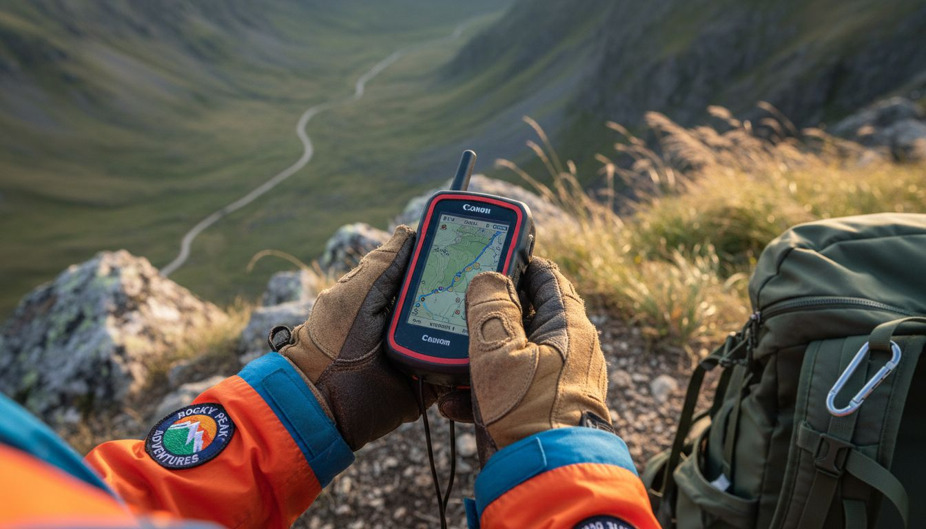
These ruggedized units work offline and display your position on downloaded topographic maps. You can mark campsites, water sources, and trailheads as waypoints, then retrace your path later.
GPS excels at tracking where you've been and preventing you from getting truly lost. Many models also log your route, helping you learn what works for future trips.
The Complete Navigation System
Smart adventurers carry all three:
- Map for route planning and terrain visualization
- Compass for direction finding when electronics fail
- GPS device for real-time position confirmation and waypoint tracking
No single tool should be your only navigation method. Weather damage, battery failure, or software crashes happen in the field.
A map, compass, and GPS device together create redundancy. If one fails, two others keep your family safe and moving forward.
When these tools work together, you move with confidence through unfamiliar territory. Your kids learn that preparation defeats panic.
Here's a comparison of the main navigation tools for outdoor adventures:
| Tool | Key Strength | Typical Limitation | Most Useful Scenario |
|---|---|---|---|
| Topographic Map | Visualizes terrain and features | Can be damaged or lost | Planning routes offline |
| Compass | Reliable, no batteries required | Requires skill to use | Direction finding in fog |
| GPS Device | Real-time location; marks waypoints | Battery life and satellite signal needed | Tracking progress in remote areas |
Pro tip: Practice using all three tools on short day hikes before longer trips. Familiarity builds confidence and reveals any equipment issues while you're close to your vehicle.
Modern Navigation Technology and Its Use Outdoors
Outdoor navigation technology has evolved far beyond basic GPS units. Modern systems combine satellite data, wireless connectivity, and intelligent processing to deliver real-time information even in remote wilderness areas where your phone has no signal.
How Modern Systems Work
GNSS technology and wireless communication form the backbone of contemporary outdoor navigation. These systems triangulate your position using satellites, then enhance that data with weather updates, route optimization, and terrain analysis.Unlike old GPS units that simply showed where you were, modern navigation systems understand dynamic environments. They adapt to terrain changes, weather patterns, and unexpected obstacles.
For Western camping trips, this means your device learns from your route. It adjusts recommendations based on elevation gains, water availability, and seasonal trail conditions.
Key Features That Matter
Modern outdoor navigation tools deliver capabilities designed specifically for wilderness use:
- Real-time weather updates showing conditions ahead on your route
- Route optimization that accounts for terrain difficulty and time estimates
- Offline functionality so you navigate without cellular service
- Multiple travel modes adapting to hiking, mountaineering, or backcountry travel
- Integration with sensors like barometers and compasses for accuracy
These features work together to keep your family safe and moving confidently through unfamiliar country.
Smart Adaptation in Dynamic Environments
Contemporary systems go beyond static mapping. Mobile devices combined with onboard learning handle large variations in outdoor appearance and environmental changes throughout the day.
Your device learns how mountain shadows affect terrain visibility at dawn versus noon. It understands how seasonal vegetation growth changes trail appearance. This adaptive intelligence prevents confusion when real terrain doesn't exactly match stored maps.
This technology matters most when conditions shift unexpectedly. A sudden storm changes visibility. Wildfire smoke alters landmarks. Snow covers trail markers. Smart systems compensate automatically.
Integration with Your Outdoor Gear
Modern navigation works best when integrated with quality equipment. Rugged GPS receivers, reliable compasses, and durable maps form a complete system where each tool supports the others.
Your smartphone's navigation app provides convenience for day hikes. A dedicated handheld GPS device offers reliability for remote backcountry trips. Offline maps downloaded to your phone create a backup system.
Modern navigation technology adapts to real conditions while maintaining the redundancy you need. Multiple tools working together create safety margins.
The technology removes guesswork from trip planning. You know exact elevation gains, realistic time estimates, and water source locations before you start.
Pro tip: Download offline maps and current weather data before heading into the backcountry, then leave your phone in airplane mode to extend battery life while maintaining navigation capability.
Practical Applications for Families Camping in the West
Navigation skills transform camping from stressful to enjoyable for Western families. When you understand how to read terrain and plan routes, backcountry adventures become something your kids actually want to do again.
Planning Your Route Before You Leave
Start with topographic maps of your camping area. Study elevation changes, water sources, and trail markers weeks before your trip.
Identify bailout points where you could safely exit if weather turns bad or someone gets injured. Mark potential campsites with reliable water access. Note ridgelines that provide navigation landmarks from distance.
This planning prevents the panic that comes from poor decisions made in the field. Your family moves with confidence because you've already thought through the hardest parts.
Reading the Landscape With Your Kids
Understanding local terrain through topographic maps and practical skills helps your family avoid disorientation in the backcountry.
Teach children to recognize contour lines showing steep slopes. Point out ridge patterns visible from camp. Show them how water always flows downhill and can guide you to lower elevations if lost.
Kids who can read terrain develop genuine confidence. They understand why you chose this pass or that valley, making navigation feel like adventure rather than adult hassle.
Real-World Navigation Decisions
Older kids can learn to:
- Take compass bearings between landmarks
- Triangulate your position using three known peaks
- Estimate distances using map scale and terrain features
- Identify natural hazards like avalanche slopes or cliff bands
- Plan daily mileage based on elevation and experience level
These skills make teens valuable contributors, not just passengers on your trip.
Emergency Preparedness and Response
Risk assessment before departure prevents emergencies. Know weather patterns for your season. Understand seasonal hazards like snow patches or water crossings.
Carry redundant navigation tools: map, compass, GPS device, and knowledge. Brief your family on what to do if someone gets separated. Mark your planned route with park rangers or trusted friends.
When everyone understands navigation principles, panic decreases dramatically. Your family knows that staying put and using maps to confirm location keeps everyone safe.
Navigation education turns outdoor emergencies from life-threatening crises into manageable challenges. Knowledge creates resilience.
Making It Stick
Practice navigation on short trips near your vehicle. Use navigation to find hidden campsites or scenic overlooks. Make it fun, not just safety training.
Families who navigate together develop outdoor competence that lasts decades. Your kids learn that preparation plus knowledge equals freedom to explore safely.
Pro tip: During each camping trip, give one family member daily responsibility for route finding using maps and compass. Rotating this role builds skills while spreading the mental load among adults.
Common Navigation Mistakes and Safety Risks to Avoid
Most camping disasters stem from preventable navigation errors. Understanding what goes wrong helps you avoid becoming a backcountry rescue statistic.
Overrelying on Electronics
Your smartphone's battery dies. GPS signals bounce unpredictably in canyons. Cloud cover blocks satellite reception. When you depend entirely on one device, you're setting yourself up for panic.
Overreliance on electronic navigation aids without backups creates dangerous situations in remote terrain where help is hours away.
Carry paper maps and a compass you actually know how to use. Test them at home before your trip. Your backup tools might be the difference between walking out versus requiring rescue.
Misreading Maps and Contours
Many families study flat elevation profiles but ignore actual contour lines. A slope that looks gradual on your phone might be a 40-degree scramble in reality.
Contour lines closer together mean steeper terrain. Missing this distinction sends you up brutal climbs or unsafe descents with young kids and heavy packs.
Spend time actually reading your maps before departure. Trace your route with a finger. Mark elevation gain milestones. Identify terrain obstacles.
Common Trail Navigation Errors
These mistakes happen regularly:
- Taking a fork without confirming it matches your map
- Assuming GPS accuracy when terrain doesn't match the signal
- Continuing forward when trail markers disappear instead of backtracking
- Underestimating distance and time on unfamiliar terrain
- Not accounting for elevation gain when calculating hiking speed
- Ignoring seasonal hazards like snow patches obscuring trails
Each one individually might cost you hours. Combined, they create genuine danger.
Weather and Exposure Risks
Weather in the Western mountains changes rapidly. Afternoon thunderstorms materialize in 30 minutes. Temperature drops 10 degrees with every 1,000 feet elevation gain.
Navigating while disoriented in bad weather causes most wilderness emergencies. Your kids get cold. Visibility disappears. Panic increases as adults make poor decisions under stress.
Turn back when conditions deteriorate. Your safety matters more than reaching your destination today.
Use this summary to help avoid common navigation mistakes:
| Mistake Type | Consequence | Prevention Tip |
|---|---|---|
| Overreliance on electronics | Loss of navigation if power fails | Carry and practice map/compass use |
| Misreading contour lines | Risk of dangerous climbs/descents | Study map features before trip |
| Ignoring weather changes | Increased exposure and emergencies | Turn back if conditions worsen |
Navigation mistakes compound quickly in the backcountry. A small error today becomes exposure to harsh weather tonight.
Building Competence Before Crisis
Practicing multiple navigation skills mitigates risks during real adventures. Use navigation games on home hikes. Challenge yourself to find obscure landmarks using only a map and compass.
When something goes wrong on a real expedition, you'll respond calmly because you've practiced the skills beforehand.
Pro tip: Before any backcountry trip, simulate getting lost with your family near your vehicle using only map and compass to navigate home. This builds real competence without actual danger.
Equip Your Family for Safe and Confident Outdoor Navigation
Navigating remote trails and unpredictable terrain is a real challenge for any family camping in the Western wilderness. As the article explains, relying solely on electronics can leave you vulnerable when batteries die or signals disappear. You need reliable, durable gear like topographic maps, compasses, and GPS devices that work together to keep your loved ones safe and confident on every adventure.
Discover how Life Camp Adventure supports your outdoor navigation goals with high-quality camping equipment and survival essentials designed for rugged use and ease of operation. Prepare now to avoid navigation mistakes that can turn a fun trip into a stressful ordeal. Visit Life Camp Adventure to explore gear that helps you plan routes, track your position, and weather the unexpected with confidence. Take the first step toward mastering outdoor navigation and make every family camping trip a safe memory worth repeating.
Frequently Asked Questions
What are the key tools needed for outdoor navigation?
You need three core tools for outdoor navigation: topographic maps for terrain visualization, a compass for direction finding without electronic assistance, and a GPS device for real-time positioning and waypoint tracking.
How can I ensure my navigation tools work without internet access?
Download offline maps and familiarize yourself with your navigation tools before heading into the backcountry. Maps and compasses don’t rely on signals or batteries, making them essential backups.
What are common mistakes to avoid when navigating outdoors?
Common mistakes include overreliance on electronics, misreading contour lines on maps, and ignoring weather changes. Always carry multiple navigation tools and study terrain features before your trip to minimize risk.
Why is understanding terrain crucial for camping safety?
Understanding terrain helps you plan safe routes and identify potential hazards, ensuring your family can navigate confidently without panic, even in unfamiliar or changing conditions.
Recommended
- Role of GPS in Outdoor Adventure Safety and Success
- Why Outdoor Safety Matters for Families
- What Is Outdoor Gear and Why It Matters
- Why Choose Camping Equipment for Adventure Success
- 7 izglītojošas āra aktivitātes Latvijā adrenalīna cienītājiem – Skydive Latvia
- Camp Safety Tips Guide For Secure And Fun Camping Trips
- 7 Top Camping Safety Tips for Every Outdoor Enthusiast – Hazli Collection